Carbonate Lithofacies Mapping
![]()
Key Benefits
| Quatitative lithofacies identification and mapping including porosity and permeability. | |
| Interfaces with all current E & P software applications. | |
| Single well and regional multiwell E & P mapping for trends. | |
| Generates an annotated well log (needs external log plotting software) for correlation. | |
| Very effective in evaluating dolomites. | |
| Software runs on any platform and is based on the SAS™ System. | |
| View a white paper describing the multivariate statistcal methodology. |
![]()
Problem Statement
This lithofacies mapping technique was applied to carbonate-bearing rocks in Mississippi, Alabama, West Texas, the Williston Basin, Oklahoma, Alaska, New Mexico, and Offshore California. A critical evaluation of those results demonstrated the validity of using the results of this software outside of the Alabama and Mississippi project area.
Most log interpretation software is designed for single well data processing. The statistical techniques used in this study enabled multi-well comparisons in an exploration setting.
Further work is needed to apply this technique to clastic rocks.
![]()
Example Projects
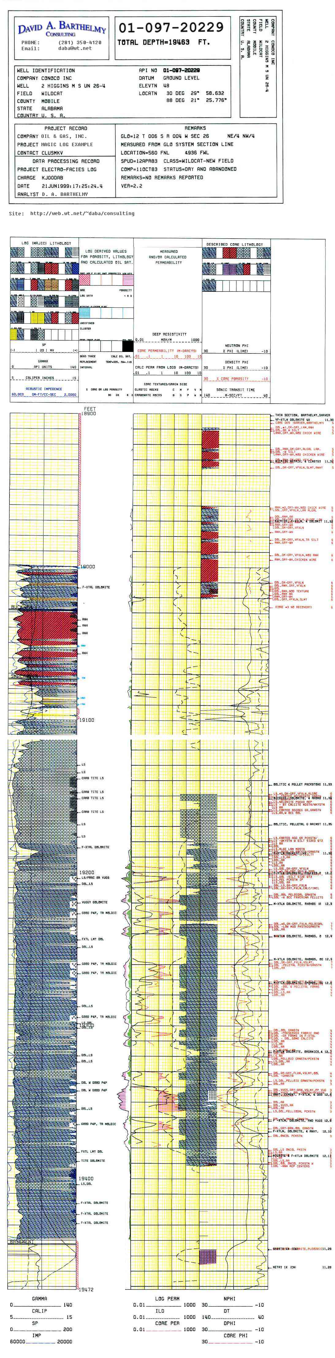
- Magic Log Example - See 20% porosity at 19,350 feet.
- Smackover Dolomites in Alabama
![]()