Smackover Dolomites
![]()
Contents:
Project Summary
| |||||
Key Features
|
![]()
Project Summary
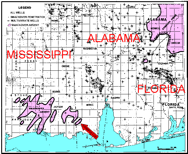
In 1987, a dry hole was drilled in the Conecuh Embayment in Alabama. This prospect was targeted to intersect an oolitic grainstone shoal on a prominent structural nose. Re-examination of our Smackover facies maps demonstrated a large error in the existing litho-facies interpretation. The development of a multi-variate facies analysis tool known as MAGIC (see a white paper on this technique) provided critical insight into the actual distribution of Norphlet, Smackover, Buchner, Haynesville, and Cotton Valley litho-facies in the project area (See Index Map).
Log and Core Data Resources In Study Area
A cursory examination of all the well data resources in Alabama shows that:
| 95% of all log data (1,200 wells) in the area were obtained after 1970. A very large majority of these wells have modern log suites. | |
| There are about 600 wells which cored the Smackover and Norphlet formations. |
The large percentage of core and modern log information has provided the statistical base needed to prove the validity of multivariate lithology identification technique.
This study used the information from 364 wells, 190 of them with cores, 12 of them by personal description of the cores, and 35 of them with extensive thin-sections (800 thin-sections). The Smackover litho-facies database contained 360,000 feet of normalized, depth adjusted induction, gamma ray, spontaneous potential, neutron porosity, density, sonic and caliper curves with 47,000 feet of core description plus core porosity and permeability data.
Index Map of Smackover Study
![]()
Key Features
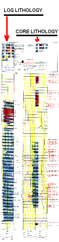
Log Display Example
The combination of log-derived lithology, core descriptions and eight composite log curves on each permanent hard copy computer-generated color geophysical log simplifies lithofacies identifications. The detail in which the representation of lithologic data is reproduced greatly improves difficult stratigraphic correlations. The example log is from the Conoco No. 2 M. S. Higgins Unit, located in section 26 of township 6 south, range 4 west, Mobile County, Alabama. Follow this link for the full scale log image (500kb size).
| Added Features |
Statistical examination of log information does the following:
Identifies bad hole and other inaccurate curve values before assignment of lithology using multivariate analysis.
Generates a missing curve or regenerates bad data in a curve by statistical inferences to a digital log database. For example, the following list represents the program's capability:
Sonic curve reconstruction from neutron, density, and induction data.
Neutron curve reconstruction from sonic, density, and induction data.
Density curve reconstruction from sonic, neutron, and induction data.
| Porosity & Permeability from Logs |
The prediction of porosity and permeability values from log data are related to core analyses by multivariate statistical regressions.
| Seismic and Mapping Integration |
Simplifies a combined stratigraphic analysis of both subsurface geological rock information and geophysical seismic information. Data from every log processed is stored in a database preserving the log processing statistical parameters. This data will interface with all types of Exploration and Production software applications for:
Additional petrophysics
Spatial display of facies elements.
Seismic attribute analysis.
Results of Smackover Study
The Oxfordian Jurassic Smackover in eastern Mississippi and Alabama varies in thickness from less than 100 to over 1,000 feet in thickness. This sequence of rocks are now buried and range in depth from 4,000 to over 20,000 feet and do not outcrop in the United States. Our subsurface analysis of lithology and lithofacies has resulted in a greater understanding of the distribution of dolomite in the buried strata.
The original aragonite ooid grainstones, pelloidal packstones and mudstones have been modified by early diagenesis from meteoric water and brine reflux from gypsum and halite saturated brines. The subsequent burial and diagenesis of these rocks formed early and late stage dolomites. These dolomites are the primary reservoir rocks of the Smackover Formation in the deeper parts of the basin.
The following list summarizes our understanding of Smackover carbonate lithofacies in the study area:
| Primary porosity in limestone grainstones and packstones gradually disappears as the result of burial. All porosity and permeability in limestones are essentially absent below 14,000 feet. | |
| Early stage dolomites (from lithofacies logs and oxygen isotope analysis) form the best reservoir rocks. These rocks are consistently medium to coarse-grained dolomites in oolitic grainstones or pelloidal packstones. Early stage dolomites retain their reservoir quality porosity-permeability characteristics into burial depths exceeding 20,000 feet. | |
| Late stage dolomites (from lithofacies logs and oxygen isotope analysis) are generally tight or poorly porous and permeable. These rocks generally formed from wackystones or mudstones. | |
| Vuggy limestones and dolomites are characterized by the presence of porosity and good permeability. Moldic limestones and dolomites are characterized by the presence of porosity and poor permeability. | |
| Hydrocarbon source rocks in the Smackover are restricted to algal-laminated mudstones and wackystones in the lower sections of the Smackover section in the study area. They are uniquely identified on the lithology logs as carbonaceous limestones or dolomites. | |
| Dolomite facies rocks in the Smackover are found in areas with thin or absent Luanne Salt. Limestone facies rocks in the Smackover are found in areas with thick Luanne Salt (Mississippi Salt Basin). |
![]()